With only a few weeks to go before the Jungfrau Marathon, Hilary wanted to hike at altitude. So we met up on a chilly summer morning in Andermatt (1436m), fuelled up with coffees, and set off, following an easy trail up through the Unteralp valley towards the Vermigel Hütte, at 2047m. We'd done this part last year, but then we went left up a crazy mountain biking trail and over to Oberalppass - Hils was in training for the Jungfrau last year too!
This time though, after a quick stop for an apple juice at the hut, we continued right, following the steep trail up towards the Sella Pass. With Hilary setting her usual cracking pace, we were above the tree line in no time at all, crossing patches of sticky snow still trapped, even at summer's end, in the high reaches of the schisty slopes. The trail, though difficult, was superb, marker rocks freshly painted with their red and white stripes and, at times, carefully laid rocks defining the trail across the schist. It's a bleak landscape up there though, made even bleaker by the damp clouds rolling in over the top of the pass. But we reached the top at last, clambering the last few metres to the Giübin lookout at 2776m. We couldn't see much through the cloud, but we were famished, so huddled under rocks to eat our meagre lunch of bread, cheese and ham.
And then it was all downhill, skirting the Sella lake, where cows were gathering for milking, and back down to Gotthardhöhe, the top of the Gotthard Pass, where James was waiting to return us to civilisation - and beers in the sun while waiting for the train home.
Showing posts with label hiking. Show all posts
Showing posts with label hiking. Show all posts
Wednesday, September 1, 2010


Tuesday, April 27, 2010
Summer returns - and so does the hiking
 A glorious April weekend loomed, so, temporarily spouseless, three of us decided to celebrate with a two-day hike in the Graubünden, selected from many on the very useful wandersite.ch website. With snow still at around 1600m we chose a low route, the first day following the Burgenweg Domleschg, and the second the "Via Spluga".
 The Burgenweg, famous, as its name suggests, for its proliferation of castles, was a gentle start to our hiking year, a three and a half hour wander through pretty villages, blossom-covered trees and flowered fields. We took a couple of detours upwards to stretch the limbs, and to continue our habit of getting "lost" on our hikes. And then we arrived in Thusis, to the welcoming and very comfortable Hotel Weiss Kreuz, in time for a beer or two on the sun-drenched terrace.
 Our helpful hostess next morning explained that there were in fact two routes we could take to our next destination, and the two vertigo-sufferers in the group, paling merely at the photo of the famous Traversiner-Steg, opted for the easier western route through the Viamala gorge, on a narrow road between touring cliffs far above the Hinterrhein, famed for its Verlorene Loch, a tunnel cut through the rock in the early 19th century which opened up the trade route. We spotted the 60 metre long Traversiner-Steg from across the gorge and agreed that, for Rebecca at least, it would have been an impossibility. I'm tempted to try it next time - another test for the vertigo that seems to be improving slightly with age.
 The rest of our walk followed the Via Spluga, through the pretty village of Zillis, famed for the 153 wooden paintings on its ceiling, depicting life in the middle ages. We ate our nuts and chocolate beside a pond broiling with tadpoles, and then made our way towards Andeer, crossing the covered wooden bridge leading into the village, stopping to buy cheese from a farm, and finally to the thermal pool, where we luxuriated in the warm waters and the stunning vistas.
 We'll be back later in the summer, I think, to continue the hike across the Splügenpass and into Italy.
Monday, August 17, 2009
Heidi Day in the Maderanertal
Another Friday, another "Heidi day" for us and our guest bloke, Gary, and we were back in Canton Uri on another gorgeous August day, this time to the Maderanertal, a stunning alpine valley with an access road that gets the adrenaline pumping. Only 3km long, the narrow road up to Bristen from Amsteg twists up a steep cliff, a vertiginous drop on one side and hairpin bends blasted through the rock. A notice top and bottom warns drivers to wait at certain times when the Postbus is taking the road - there's certainly no room to pass it.
True to form, we got lost almost immediately, taking the high road across the valley. Our extra ascent had its advantages though, not only distancing us from the many other hikers and cyclists, but also providing us with untouched treasure troves of wild strawberries, raspberries and blueberries. Back on the trail proper, we climbed again, passing the 150 year old Maderanertal Berghotel. Coffee on a sunny terrace beckoned, but we ignored the call, instead taking the trail straight up the mountain to the Windgallenhütte 1000m above. Some thoughtful person had added the warning "sehr steilen Bergweg" (very steep mountain path) to the yellow signpost, but we ignored this too, marching up a near-vertical trail, grateful for our Leki sticks as we clambered ove r rocks and roots, pausing for lunch near the top as the trail began to level out. Despite burning lungs and legs, we were grateful we weren't attempting to walk down this hazardous path - and watched in amazement as a couple of elderly locals cheerfully set off down it with only their wooden sticks to help them.
Perched at 2032m, high above the valley and with superb views across to the glacier covered Oberalpstock, the Windgallenhütte was a perfect drink stop before our more gentle descent to the Golzernsee, and a refreshing soak in the lake's cool waters before we took the cable car down to the valley and another hair-raising, bus-beating journey back to Amsteg.
True to form, we got lost almost immediately, taking the high road across the valley. Our extra ascent had its advantages though, not only distancing us from the many other hikers and cyclists, but also providing us with untouched treasure troves of wild strawberries, raspberries and blueberries. Back on the trail proper, we climbed again, passing the 150 year old Maderanertal Berghotel. Coffee on a sunny terrace beckoned, but we ignored the call, instead taking the trail straight up the mountain to the Windgallenhütte 1000m above. Some thoughtful person had added the warning "sehr steilen Bergweg" (very steep mountain path) to the yellow signpost, but we ignored this too, marching up a near-vertical trail, grateful for our Leki sticks as we clambered ove
 r rocks and roots, pausing for lunch near the top as the trail began to level out. Despite burning lungs and legs, we were grateful we weren't attempting to walk down this hazardous path - and watched in amazement as a couple of elderly locals cheerfully set off down it with only their wooden sticks to help them.
Perched at 2032m, high above the valley and with superb views across to the glacier covered Oberalpstock, the Windgallenhütte was a perfect drink stop before our more gentle descent to the Golzernsee, and a refreshing soak in the lake's cool waters before we took the cable car down to the valley and another hair-raising, bus-beating journey back to Amsteg.
Sunday, August 9, 2009
Hiking in Andermatt
Hiking buddy Hilary planned to spend the weekend at her Andermatt apartment, so we joined her there for our Friday hike, Gary given temporary girl status and allowed to join us. The original plan was to tackle the Gemsstock, but when we saw the dotted blue line on the map that indicates serious alpine hiking, and read about a vaguely terrifying "transverse", my vertigo began to kick in at the mere prospect of crossing that glacier.
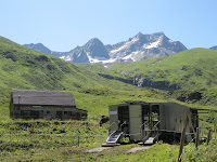
So the plan was modified to a five and a half hour circuit of the Unteralptal, up through Maighelspass to Oberalppass and then a train back down to Andermatt. We started with an easy stroll up the valley, dogs Molly and Albi occasionally dashing off in pursuit of marmots, those silly creatures that sit atop rocks and chirp, too much for any self-respecting terrier to ignore. Towards the end of the otherwise deserted valley we came across a tiny alpine farming settlement, with cows and mobile milking shed to one side, and clambering across the steep hill to the other side, a flock of sheep several times larger than any I've previously seen in Switzerland, more reminiscent of a New Zealand high country farm, with shepherd and dogs in residence high above us.
Lunch was at the Vermigelhütte, at 204 2m already 600m above Andermatt, and from there it was a steep and rocky climb another 400m to the top of the Maighelspass. Relatively easy for us with our leki sticks, but incredibly challenging for a number of cyclists making their way down the rocky trail. Most got off and walked, but several just bounced on down, mud-spattered, helmeted and completely crazy. "Twice in the last half hour", sighed one guy, changing his rock-punctured tire near the top. It was a specta
 cular hike, though, brilliant blue alpine bluebells lining the trail up, tiny lakes and moors dotted over the high passes, and the occasional patch of deep snow remaining from the winter.
A long trek down the Oberalppass, the winding, undulating rail at the end of the pass busy with day-trippers, brought us to the station and t he Matterhorn-Gotthard train. Strangely familiar, this little platform and the cog railway lines - I'd skied here in February, a very different scene and temperature. The lake now rimmed with fishermen was then frozen and snow covered, and we huddled out of the biting wind in the small waiting room. Back then we left the train at the top of the road down to Andermatt and skied down the long trail, but this time we stayed on for the steep drop down to our cold beers and the train home.

So the plan was modified to a five and a half hour circuit of the Unteralptal, up through Maighelspass to Oberalppass and then a train back down to Andermatt. We started with an easy stroll up the valley, dogs Molly and Albi occasionally dashing off in pursuit of marmots, those silly creatures that sit atop rocks and chirp, too much for any self-respecting terrier to ignore. Towards the end of the otherwise deserted valley we came across a tiny alpine farming settlement, with cows and mobile milking shed to one side, and clambering across the steep hill to the other side, a flock of sheep several times larger than any I've previously seen in Switzerland, more reminiscent of a New Zealand high country farm, with shepherd and dogs in residence high above us.
Lunch was at the Vermigelhütte, at 204
 2m already 600m above Andermatt, and from there it was a steep and rocky climb another 400m to the top of the Maighelspass. Relatively easy for us with our leki sticks, but incredibly challenging for a number of cyclists making their way down the rocky trail. Most got off and walked, but several just bounced on down, mud-spattered, helmeted and completely crazy. "Twice in the last half hour", sighed one guy, changing his rock-punctured tire near the top. It was a specta
 cular hike, though, brilliant blue alpine bluebells lining the trail up, tiny lakes and moors dotted over the high passes, and the occasional patch of deep snow remaining from the winter.
A long trek down the Oberalppass, the winding, undulating rail at the end of the pass busy with day-trippers, brought us to the station and t
 he Matterhorn-Gotthard train. Strangely familiar, this little platform and the cog railway lines - I'd skied here in February, a very different scene and temperature. The lake now rimmed with fishermen was then frozen and snow covered, and we huddled out of the biting wind in the small waiting room. Back then we left the train at the top of the road down to Andermatt and skied down the long trail, but this time we stayed on for the steep drop down to our cold beers and the train home.
Friday, July 31, 2009
Knocking off the Gemmenalphorn
It's Friday, normally a hiking day, but for various reasons our little hiking group i sn't out there today, so I'm filling the space with recollections of last week's hike, a five hour trek from Beatenberg up to the Gemmenalphorn and down to Niederhorn. The Gemmenalphorn, soaring above the Thunersee at 2061m, features in my friend and hiking companion Hilary's book of Switzerland's beautiful mountains, all of which we're attempting to "knock off", in the immortal words of that other high-flying Hillary, Sir Ed.
We started at Beatenberg, and the first couple of hours were a doddle, a stroll through an alpine valley of streams and freshly cut meadows. At the head of the valley was a "Beizli" selling alp cheese, so we stopped to buy some, stepping back a few centuries into a dark cellar with wood fire burning under a huge copper cauldron of curdling milk. After this our path went up, steep and tortuous, to a flower-covered plateau, and lunch on a sun-warmed rock. Then came
 the assault on the Gemmenalphorn, truly a "horn", a rock needle up which we threaded, passing a family of ibex en route. Alert but calm, they sat beneath their rock staring at us sweaty, camera-waving humans. We came across several more of these majestic creatures, some perched atop rocks, others resting with their young in the shade, as we clambered from one peak to the next, until eventually the trail flattened out to another plateau leading to the Niederhorn cable car, back down to Beatenberg and a welcome beer.
 sn't out there today, so I'm filling the space with recollections of last week's hike, a five hour trek from Beatenberg up to the Gemmenalphorn and down to Niederhorn. The Gemmenalphorn, soaring above the Thunersee at 2061m, features in my friend and hiking companion Hilary's book of Switzerland's beautiful mountains, all of which we're attempting to "knock off", in the immortal words of that other high-flying Hillary, Sir Ed.
We started at Beatenberg, and the first couple of hours were a doddle, a
 stroll through an alpine valley of streams and freshly cut meadows. At the head of the valley was a "Beizli" selling alp cheese, so we stopped to buy some, stepping back a few centuries into a dark cellar with wood fire burning under a huge copper cauldron of curdling milk. After this our path went up, steep and tortuous, to a flower-covered plateau, and lunch on a sun-warmed rock. Then came
 the assault on the Gemmenalphorn, truly a "horn", a rock needle up which we threaded, passing a family of ibex en route. Alert but calm, they sat beneath their rock staring at us sweaty, camera-waving humans. We came across several more of these majestic creatures, some perched atop rocks, others resting with their young in the shade, as we clambered from one peak to the next, until eventually the trail flattened out to another plateau leading to the Niederhorn cable car, back down to Beatenberg and a welcome beer.
Thursday, July 30, 2009
Hiking the Strada Alta
Every summer, on the last weekend in July, the park in front of our house hosts the Seenachtsfest, a three day event of carnival rides, music and beer tents that bumps and grinds into the wee hours and penetrates the densest of earplugs. This year, with Gary away in Nairobi again, I planned an escape down to sunny Ticino, in the southern, Italian part of Switzerland. I'd heard about the Strada Alta, a 45km hike from Airolo to Biasca along the old track used by muleteers on the Gotthard route, and this seemed like the perfect opportun ity to check it out.
My friend Rebecca offered to join me, sparing me the deafening silence of my own company, so, backpacks stuffed with essentials (spare knickers and socks, books and a pack of cards), we took the train down to Airolo on a glorious Saturday morning, smug and comfortable above the morning's already several kilometre long queue of cars waiting to go through the Gotthard tunnel.
Airolo's cafes were packed with hikers and cyclists, and we joined them for an espresso before setting out on the first leg of our journey. It was deceptively easy, that first 17 kilometres, most of it on small roads or trails, and like all Swiss trails, well marked and signposted. We passed through pretty villages and steep alpine meadows, stopping for iced tea at a friendly little osteria, filling our water bottles with icy mountain water from the ubiquitous and oh so welcome water troughs. Lunch was a Ticino platter, a feast of finely sliced local cured meats and cheeses, with delicious tomatoes and bread, washed down with a beer on the shady terrace of another hospitable osteria.
Our first overnight was in Osco, where dour service, shoebox rooms, a lacklustre meal, and a sleep-disturbing proximity to churchbells briefly dimmed our enthusiasm for our Italian Swiss neighbours. Back on the trail, however, our spirits lifted as we strode out on glorious paths, passing from sunny meadows into cool beech and pine forests. This was to be a shorter day, but, assiduously following all the signs, we took the high and hungry route, clambering up and down steep, rocky paths which bypassed the villages with osterias. We were rewarded, on this less-travelled route, by banks of wild raspberries and strawberries, their startling sunbursts of sweetness keeping us going until Anzonico, our second destination.
This was much better, the friendly little Osteria Anzonico offering another huge Ticinese platter to hungry hikers, this time lubricated by a couple of flasks of merlot. Our room was large and comfortable, opening onto a terrace where we lounged with our b ooks, tired legs at rest, until it was time to eat again. A peaceful night, only a distant echo of cowbells lulling us to sleep.
And on to Biasca, more raspberry-lined wooded trails taking us into the gorges of Vallone, a challenging section of wild river crossings and vertiginous cliff trails. As we began the steep descent into the valley we bought a jar of delicious honey, redolent with the alpine summer smells of fresh cut grass and alpine flowers, a tasty memento of our journey.
 ity to check it out.
My friend Rebecca offered to join me, sparing me the deafening silence of my own company, so, backpacks stuffed with essentials (spare knickers and socks, books and a pack of cards), we took the train down to Airolo on a glorious Saturday morning, smug and comfortable above the morning's already several kilometre long queue of cars waiting to go through the Gotthard tunnel.
Airolo's cafes were packed with hikers and cyclists, and we joined them for an espresso before setting out on the first leg of our journey. It was deceptively easy, that first 17 kilometres, most of it on small roads or trails, and like all Swiss trails, well marked and signposted. We passed through pretty villages and steep alpine meadows, stopping for iced tea at a friendly little osteria, filling our water bottles with icy mountain water from the ubiquitous and oh so welcome water troughs. Lunch was a Ticino platter, a feast of finely sliced local cured meats and cheeses, with delicious tomatoes and bread, washed down with a beer on the shady terrace of another hospitable osteria.
Our first overnight was in Osco, where dour service, shoebox rooms, a lacklustre meal, and a sleep-disturbing proximity to churchbells briefly dimmed
 our enthusiasm for our Italian Swiss neighbours. Back on the trail, however, our spirits lifted as we strode out on glorious paths, passing from sunny meadows into cool beech and pine forests. This was to be a shorter day, but, assiduously following all the signs, we took the high and hungry route, clambering up and down steep, rocky paths which bypassed the villages with osterias. We were rewarded, on this less-travelled route, by banks of wild raspberries and strawberries, their startling sunbursts of sweetness keeping us going until Anzonico, our second destination.
This was much better, the friendly little Osteria Anzonico offering another huge Ticinese platter to hungry hikers, this time lubricated by a couple of flasks of merlot. Our room was large and comfortable, opening onto a terrace where we lounged with our b
 ooks, tired legs at rest, until it was time to eat again. A peaceful night, only a distant echo of cowbells lulling us to sleep.
And on to Biasca, more raspberry-lined wooded trails taking us into the gorges of Vallone, a challenging section of wild river crossings and vertiginous cliff trails. As we began the steep descent into the valley we bought a jar of delicious honey, redolent with the alpine summer smells of fresh cut grass and alpine flowers, a tasty memento of our journey.
Subscribe to:
Posts (Atom)
